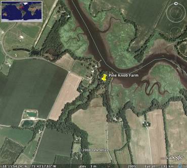
Pine Knob Farm
Topic: Eastern Shore
When we went to school everyone had some connection to everyone else, something that isn't really true of Salisbury any longer.
My grandmother had a farm east of Mt. Vernon just south of the Wicomico Creek (photo) where I spent a lot of time growing up. It was off Polk's Road, and on old maps the farm is known as Polk's Landing--it is at the constriction in the creek above under the word Pine. Pine Knob Farm was on the market again two years ago and Alison and I went back mostly to relive old memories, as it was just too expensive and far away. However, I did some research on it--John Polk of Havre de Grace filled me in. The property sold, Alison thinks to a speculator. It was still just about as it was when I had last been there, in the late 50s, and needed LOTS of work.
In any event, from what John told me:
'In the late 18th century one William Polk held lands on the south side of the Wicomico creek about a mile downstream of Pine Knob Farm, in eastern Mount Vernon, pieces from a few ancient patents. A couple of landings were mentioned in that vicinity in resurvey patents and deeds. Cited are "the Big Landing" and "William Polk's Landing", which are on the old patent WILLIAMS LOT. But nothing is seen offhand through the early 19th century which connects the Polks to Pine Knob Farm, which would have been on or very near the original survey TONYS VINEYARD's abutment with the creek (and its successors).
Less than a mile upstream from Pine Knob Farm, also on the south side, was Chapel Landing, mentioned in the survey EDINBURGH, consolidating from several earlier patents.
I just see nothing at Polk Landing/Pine Know Farm, so it seems that if a Polk owned the site it was sometime after about 1810.
The land immediately downstream (west) of Polks Landing was originally patented as TAUNTON DEANE for 300 acres in 1665. It was sold to Francis Roberts in 1668 and resold to Benjamin Cottman in 1670. The tract was involved in various conveyances and resurveys in 18th century but mostly remained in Cottman family. In 1816 the tract BELLVILLE was patented as a resurvey for 615 acres incorporating most of the orignal TAUNTON DEAN, together with other parcels, by William Bell, husband of Benjamin's descendant Arimintha Cottman.
Alongside Wicomico Creek on this tract sits a colonial era house which in the 20th century was given the name Whitehall. There is an article about it in Paul Touart's "Somerset, An Architectural History", p.223. According to an article that appeared in Baltimore Sun Magazine 3 Nov 1974, this house was originally built in 1760 for James Polk, husband of Benjamin Cottman's daughter Betty Cottman. James was born in 1700, so this was fairly late in his life - he died in 1771, and Betty in 1780. He was the father of the William Polk that John Lyon mentions as having land a bit further downstream at WILLIAMS LOT, (also ROBINSONS LOT and COW PASTURE). The lands of these two Polks along the south side of Wicomico Creek no doubt gave rise to the name Polks Road that runs along the south of the properties about a mile or two inland from the creek.
I haven't seen any mention of James Polk in the land records for TAUNTON DEANE or the other parcels comprising BELLVILLE, so I don't have any data to corroborate the statement made in the Sun Magazine. I believe that information was provided by the owners at that time, Mr. & Mrs. Miller White. It seems James Polk never owned it but lived there per some unrecorded arrangement with his father-in-law. If true this no doubt explains the origin of the name Polks Landing.
James Polk was the son of William Polk and grandson of Robert and Magdalen Polke, the first Polk family immigrants in America, who settled at Dam Quarter in 1687.'
Posted by astral
at 10:09 AM EDT
Updated: Friday, 30 July 2010 10:32 AM EDT

 The food was quite fine, service wonderful but cash only curbed our appetite a bit. An hour later, stuffed, we headed back to the Bay to return home. We decided to stop by Broad Creek to top off our tank (16g) before heading home--watch out they close at 4:30 but Darby did manage to catch the fellow minding the store as he headed home and we got our fill. Home at last, arriving just as the clock struck 5pm. We had traveled about 45 miles all told and had a great adventure.
 A moment late we were running down the stairs under evacuation warning. I was last out, as usual, just after an announcement that an inspection had declared the building sound. There were some local power outages; cell phone service was lost or overloaded. The new President was sworn in.